Solihull Motorway Service Area
An outline planning application for a Motorway Service Area (MSA) alongside the M42 between Junctions 5 and 6 was submitted to Solihull Metropolitan Borough Council (SMBC) as Local Planning Authority (LPA) on 30 June 2015. The proposed development will address a significant gap in the provision of MSAs on the West Midlands section of the UK Motorway Network, meeting an acknowledged ‘need’ for a new MSA on the Solihull section of the M42.
Since submission and in response to comments from consultees, local stakeholders and the local community, changes have been made to the scheme, the most significant of which arises from the recent (May 2020) approval of the Highways England Junction 6 Improvement scheme, work on which has now commenced.
This website provides an overview of the MSA scheme for which planning permission is being sought and confirms its associated benefits. All matters, save for defined access components, are reserved for subsequent detailed approval, including appearance, landscaping, layout and scale.
The planning application documentation is available on the Council’s website under Planning Application Number PL/2015/51409/PPOL.
The Site and Proposals
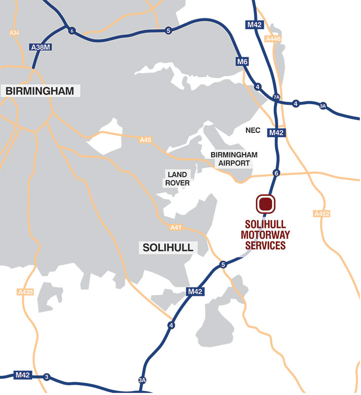
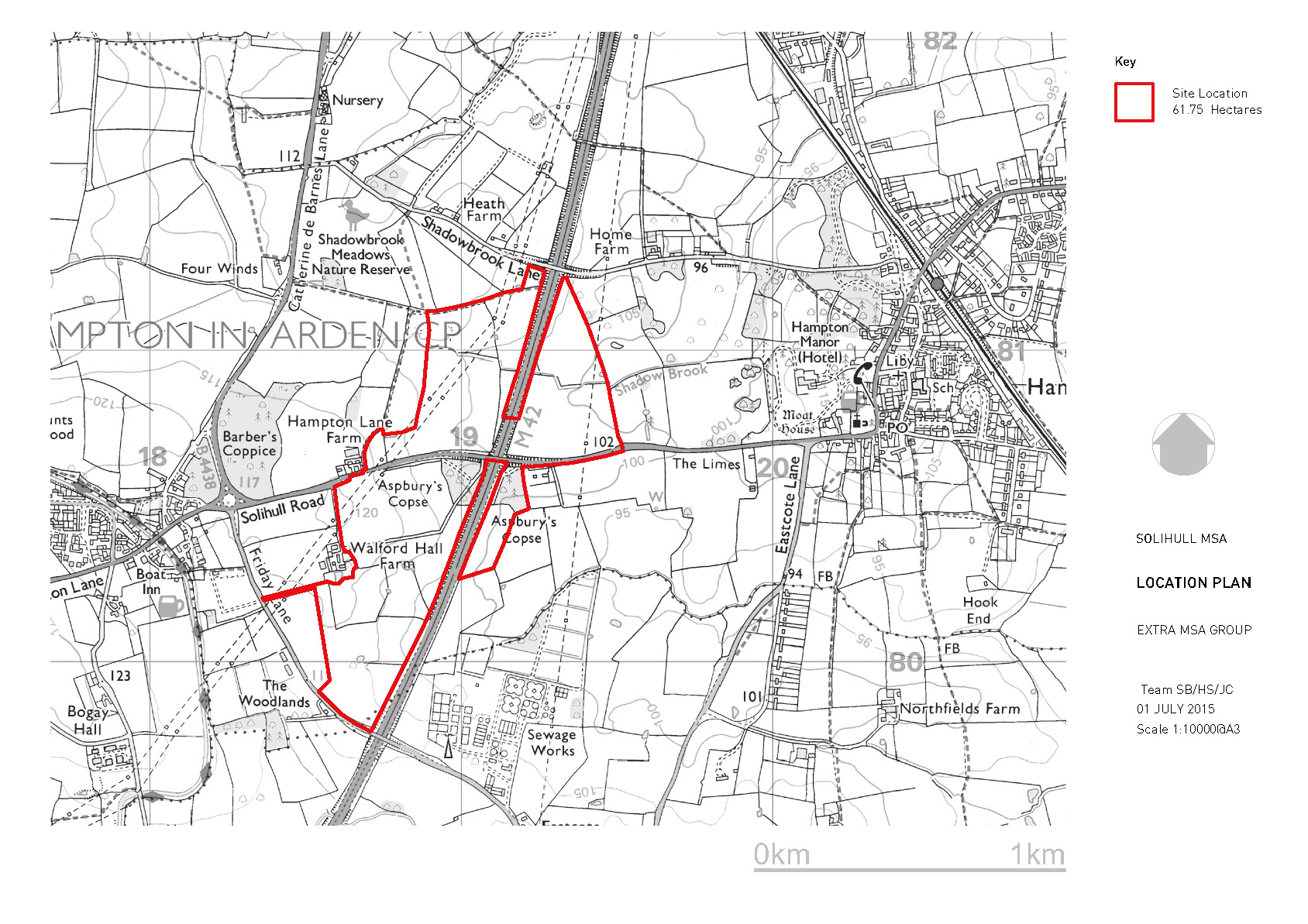
The outline planning application seeks approval for the development of a Motorway Service Area (MSA) on land between Junction 5 and 6 of the M42 Motorway. The site, which is predominantly in agricultural use, is located adjacent to the M42 to the east of the village of Catherine de Barnes and west of the village of Hampton in Arden. Solihull Road crosses the site in an east – west direction. The site’s location is shown on the plans to the right.
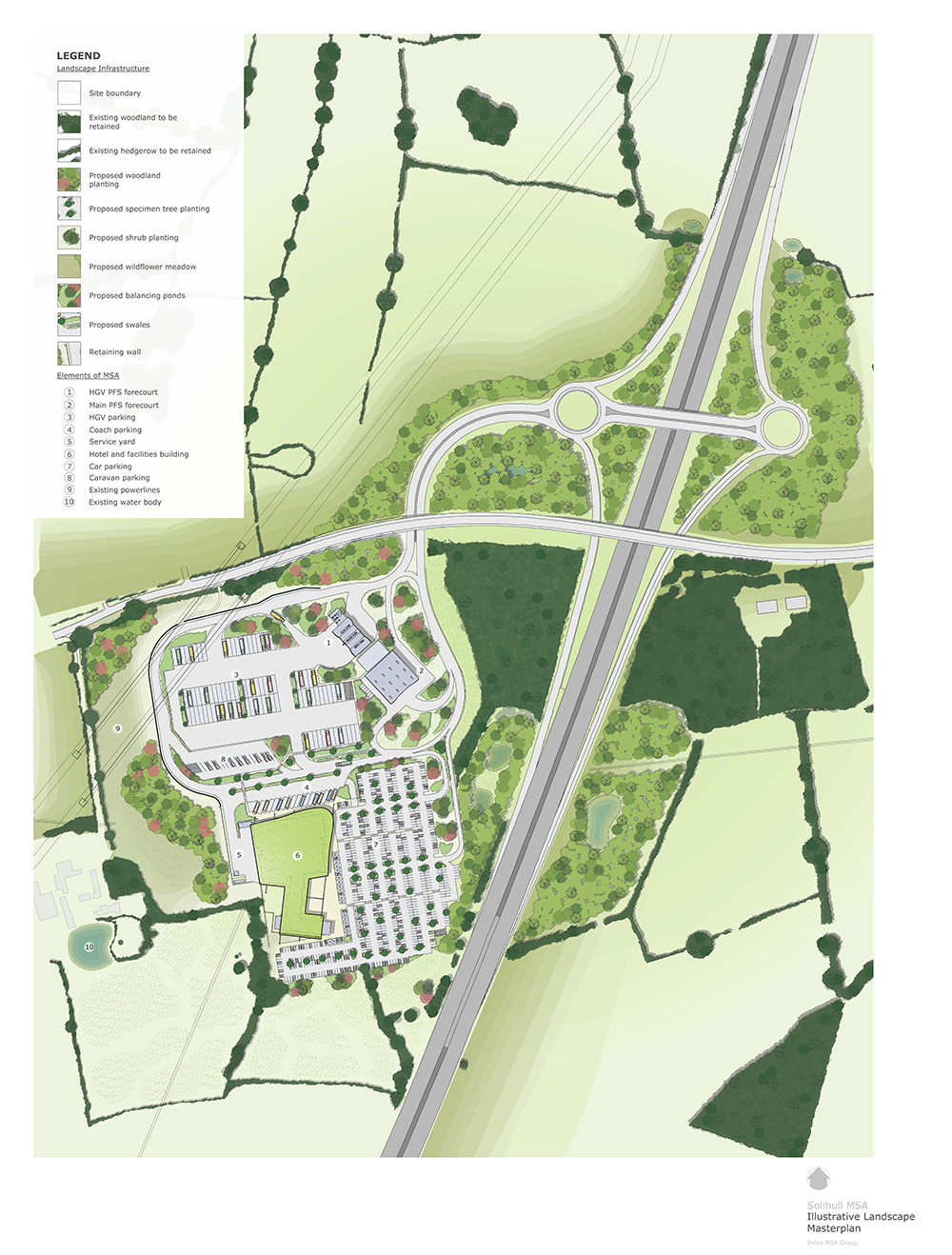
The overall site area is approximately 61.75 hectares, the majority of which would be landscaping and woodland. An Illustrative Masterplan forms part of the application and shows how the proposals could be laid out and how access would be gained. (This can be found to the right).
The MSA development would be located to the west of the M42 and south of Solihull Road and comprise the following:
- a facilities building, with 100 bedroom hotel and connecting link
- a fuel filling station, with separate areas for cars and HGVs
- parking for all vehicle types including HGVs, cars, caravans and coaches, including disabled spaces
- Provision of alternative fuels, including Ionity EV ‘ultra fast’ charging
- extensive enhanced landscaped areas
- highways access and circulation roads
- ancillary works such as drainage and utilities
A landscaping and planting scheme, along with the management of two areas of ancient woodland (Aspbury’s Copse and Barber’s Coppice) forms a key element of the application.
The MSA proposals do not result in any loss of ancient woodland or veteran trees.
Access to the MSA would be via the new M42 Junction 5a which will be constructed as part of the Highways England Junction 6 Improvement Scheme. Some works will be required to the design of the new Junction 5a to safely accommodate MSA traffic; these changes are included within the MSA planning application. A new MSA access road would connect the new Junction 5a and MSA development. This road would pass beneath Solihull Road to access the MSA site. There would be no vehicular connection between the MSA and Solihull Road.
Planning and Listed Building Consent (Reference Number PL/2018/02353/LBC and PL/2018/02352/PPFL) has been secured for the repair and restoration of the Grade II* Listed Walford Hall Farm House and its associated outbuildings and their change of use to commercial / office use. These applications can be viewed on the Council’s website. Completion of these works would be linked to any consent for the proposed MSA through a Section 106 agreement.